The A303 Stonehenge Examiners recommended refusal. Why?

ExA 5.7.224 “… the roads could be removed at any time, should a satisfactory scheme be put forward just as the A344 was removed …” Photo: Highways England Photo Library 2020
The Examining Authority (ExA) recommended refusal on grounds of damage to heritage, landscape and culture.
The Examining Authority’s report and recommendations can be found here.
Extracts are copied below. The illustrations, images and hyperlinks are sourced from Highways England, and the references and captions have been inserted by the Stonehenge Alliance. For the List of Abbreviations please see Appendix C.

The panel of five independent inspectors, known as the Examining Authority, opened the Examination of the draft DCO (Development Consent Order) for the A303 Stonehenge road scheme at a Preliminary Meeting held at Salisbury Race Course on 2 April 2019. Photo: Stonehenge Alliance
Examining Authority arrangements
The Examining Authority (ExA) comprised a panel of five experienced independent planning inspectors appointed by the Planning Inspectorate, an arm’s length Government Agency, to make recommendations to the Transport Secretary on the draft Development Consent Order (DCO) for the A303 Stonehenge road scheme. The Examination began with a Preliminary Meeting at Salisbury Race Course on 2 April 2019 at which the ExA introduced the procedures for participation to statutory bodies and those who had made relevant representations to the panel.
The Examination was completed six months later on 2 October 2019, the ExA having visited view points and construction sites, listened to detailed evidence from stakeholders, specialists, residents, NGOs and members of the participating public, and questioned the applicant on issues and queries raised. The ExA’s recommendation was submitted to the Transport Secretary on 2 January 2020 and published by the Planning Inspectorate following the Transport Secretary’s decision on 12 November 2020.
Overview – Extract from ExA report [1]
The Proposed Development comprises construction of a new two-lane dual carriageway for the A303 between Amesbury and Berwick Down. Key elements are:
• A northern bypass of Winterbourne Stoke with a viaduct over the River Till valley;
• A new junction between the A303 and A360 to the west of, and outside, the World Heritage Site (WHS), replacing the existing Longbarrow roundabout;
• A tunnel approximately 2 miles (3.3 kilometres (km)) in length past Stonehenge; and
• A new junction between the A303 and A345 at the existing Countess roundabout.
Summary of Recommendation:
The Examining Authority recommends that the Secretary of State should withhold consent. If, however the Secretary of State decides to give consent, then the Examining Authority recommends that the Order should be in the form attached. [2]
HERITAGE IMPACTS
The panel of five specialist planning inspectors said the scheme would introduce “a greater physical change to the Stonehenge landscape than has occurred in its 6,000 years as a place of widely acknowledged human significance.” #5.7.225
Western Cutting and Portal
World Heritage Site Outstanding Universal Value
5.7.219. The photomontages supplied by the Applicant generally show the cutting and portal from viewpoints some distance away and suggest its visual absorption into the landscape. However, concerns revolve not so much around appearances from static mid and far distance viewpoints, as the presence of the cutting in the context of an unparalleled historic landscape.
5.7.220. In addition, illustrations shown on the Structures drawings of the portal (Sheets 7 and 8 of [APP-017]), and the Illustrated Examples of Key Design Elements in OEMP Annex A.4 [AS-129], both show aerial views of the western approach and portal, with the decommissioned A303 in pedestrian use as a byway. These give an idea of the scale of the cutting, as a very major engineering element, and also of its proximity to the decommissioned A303 byway.
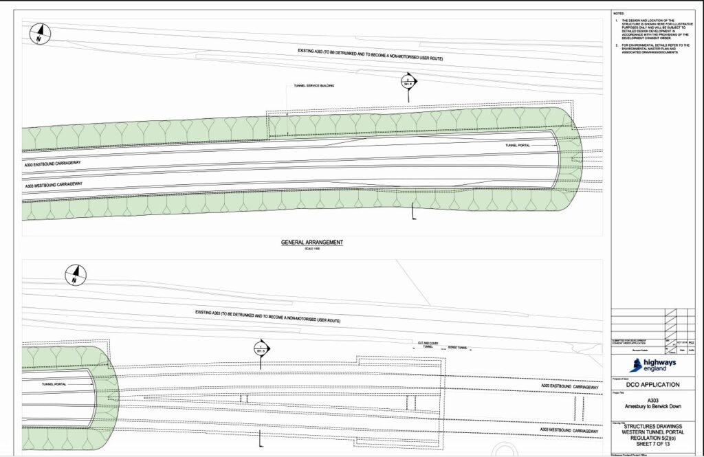
Sheet 7 [APP-017] showing proximity to the decommissioned A303 byway. Source: Highways England draft DCO
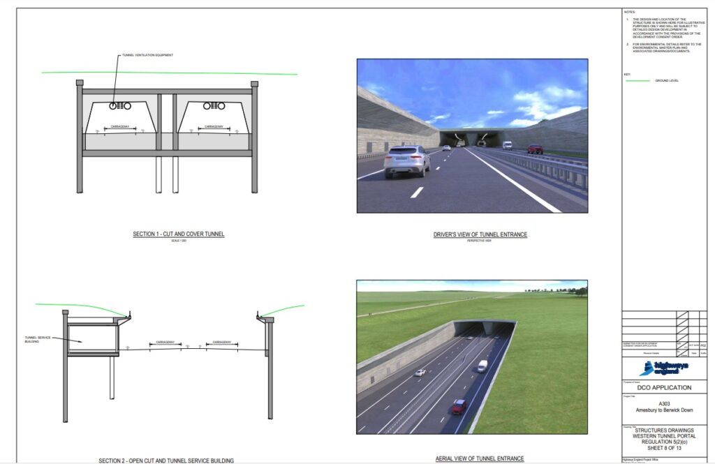
Sheet 8 [APP-017] Showing the scale of the engineering element. Source: Highways England draft DCO
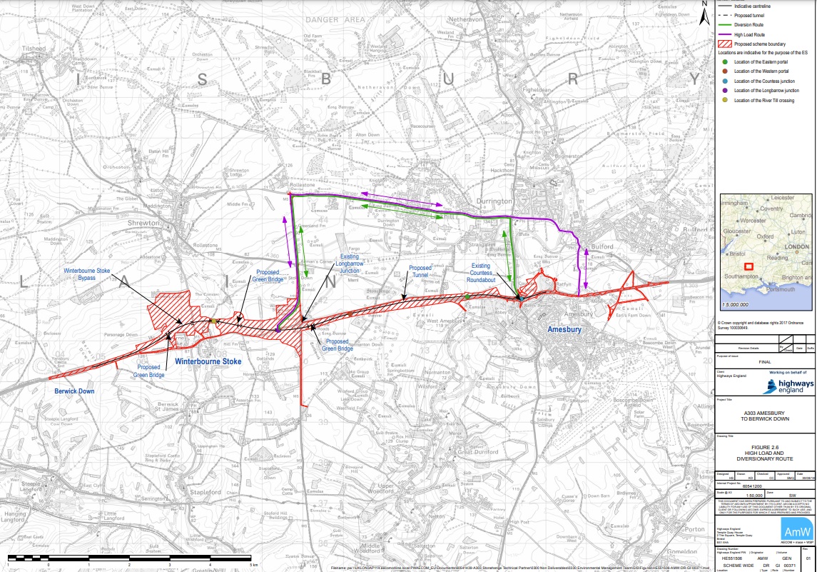
Location plan of construction zones in red and hatching. Purple and green lines denote an alternative route through Larkhill for diversions when the tunnel is closed for maintenance and incidents as well as oversized vehicles. Highways England map from draft DCO.
5.7.221. At the design location of the portal (Chainage 7200), in broad terms the cutting would be 35m wide between retaining walls and 10 to 11m deep, with an overall width of 60m from edge to edge of the sloping grass embankments. At that point, the decommissioned A303 would be only 20m from the permanent fence line along the edge of the embankment, and only 35m from the cutting’s retaining wall. These dimensions were set out in SWQ LV.2.3 [PD-014], to which the Applicant responded at [REP6-030].
5.7.222. Moreover, as can be seen from the aerial views, sections of the existing A303 running alongside the footprint of the proposed cutting are embanked above the natural ground level. This would give the cutting greater visibility to users of the byway, with the likelihood of views directly into the cutting and into the entrance to the tunnel.
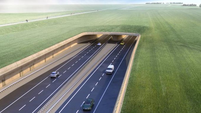
Western portal showing A303 as a resurfaced raised byway. “5.7.225: … the current proposal for a cutting would introduce a greater physical change to the Stonehenge landscape than has occurred in its 6,000 years as a place of widely acknowledged human significance. Moreover, the change would be permanent and irreversible.” Image source: Highways England Booklet 2019
5.7.224. . . . The ExA accepts that much harm arises from the effects of the existing roads, including the presence of the A303 as a major intrusive element within the Wilsford/Normanton dry valley. However, the roads could be removed at any time, should a satisfactory scheme be put forward, just as the A344 was removed, leaving little permanent effect on the cultural heritage of the Stonehenge landscape.
5.7.225. On the other hand, the current proposal for a cutting would introduce a greater physical change to the Stonehenge landscape than has occurred in its 6,000 years as a place of widely acknowledged human significance. Moreover, the change would be permanent and irreversible.
5.7.226. Turning to the effects of the western cutting and portal on the OUV of the WHS, the following OUV Attributes would be particularly affected: [3]
5.7.227. Attribute 3: The siting of Neolithic and Bronze Age funerary and ceremonial sites and monuments in relation to the landscape. The relationship of sites and monuments to the landscape would be greatly harmed by the cutting’s effect on the Wilsford/Normanton dry valley both through its intervention in the landscape settings of the monuments, and the change brought about to the Early Bronze Age route to Stonehenge, flanked by significant arrays of monuments
5.7.228. Attribute 5: The siting of Neolithic and Bronze Age funerary and ceremonial sites and monuments in relation to each other. This attribute addresses the relationship of the monument groups either side of the Wilsford/Normanton dry valley and the significant space they create between them. The relationship would be greatly harmed by the substantial spatial intervention and visual disturbance arising from the cutting.
5.7.229. Attribute 6: The disposition, physical remains and settings of the key Neolithic and Bronze Age funerary, ceremonial and other monuments and sites of the period which together form a landscape without parallel. The overall assembly of monuments, sites, and landscape would suffer major harm through the excavation of a deep wide slot in its midst. Although attempts have been made to mitigate its visual effects from the far and middle distance, its presence would represent a fundamental physical change of a scale not previously experienced.
Longbarrow Junction WHS
Outstanding Universal Value and Settings
5.7.240. The setting of the WHS contributes to its significance, because of the continuity of the monumental landscape, just as the settings of the individual monuments and groups beyond the WHS contribute to their significance.
5.7.241. The Longbarrow Junction would fall firmly within the settings of the WHS as a whole, and of AG12 and AG 13. In other circumstances, areas to the west of the A360 might have been incorporated in a WHS buffer zone (ICOMOS-UK response to SWQ LV.2.1 in [REP6-054]). It is also possible that the WHS boundary might, in the future, be extended to the west and north following a review of boundaries being contemplated (Applicant’s response to FWQ CH.1.58 [REP2-025]). [4, 5, 6, 7]
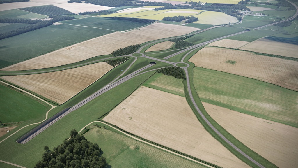
5.7.243: “… the Junction would, in the view of the ExA, dwarf all other individual features, including the Stones.” Highways England Media Library 2020
5.7.242. The Longbarrow Junction would be largely sunk into the ground, feeding the realigned A303 into the cutting leading to the western portal, and requiring similar depths of excavation of up to 11m [ES Chapter 7, para 7.9.11]. Those elements remaining at or near ground level, such as the realigned A360, Green Bridge 3 and associated roundabouts, would be masked by false cuttings of up to some two metres high. The earthworks would be contoured into the existing landscape, and some tree planting would be used as visual screening.
5.7.243. The Proposed Development photomontages, generally taken from the far and middle distance, show the Junction largely absorbed into the landscape. However, the junction would be of motorway scale, involving substantial earthworks. Seen from above, as the Stonehenge landscape was for the first time in the early twentieth century leading to the discovery of many features and enhanced appreciation of its interconnected significance, the Junction would, in the view of the ExA, dwarf all other individual features, including the Stones.
5.7.244. Moreover, its broad geometric outlines, defined by hedges and land form following road curves, would be evident at surface level. Such a pattern would appear at odds with the surrounding smaller scale morphology of rectilinear fields and small groupings of traditional buildings.
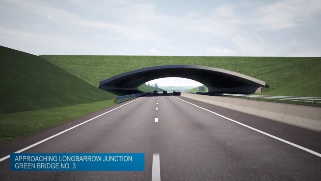
5.7.245. The Junction, together with the cutting leading to the western portal, represents a single, very large, continuous civil engineering undertaking, spanning the western boundary of the WHS. Given the arbitrary nature of the boundary and the underlying expansive and unified character of the cultural landscape, the junction would have effects on the OUV similar to those described for the cutting and western portal.
5.7.247. The harm reflects that caused by the cutting on the OUV, including a continuation of the harm to the Wilsford/Normanton dry valley. Also, the harm to the overall assembly of monuments, sites, and landscape through major excavations and civil engineering works, of a scale not seen before at Stonehenge. Whilst the existing roads could be removed at any time, should a satisfactory scheme be put forward, leaving little permanent effect on the cultural heritage of the Stonehenge landscape, the effects of the proposed junction would be irreversible.
WHS OUV and the Historic Environment as a whole
5.7.306. The overall effect of the Proposed Development on each of the OUV Attributes is assessed as follows: [3]
5.7.307. Attribute 1: Stonehenge itself as a globally famous and iconic monument. The tunnel would remove the intrusion of trunk road traffic, allow partial reunification of the WHS, and reconnection of the Avenue. However, the recognised importance of Stonehenge would suffer were the major permanent and irreversible engineering works proposed to take place within the WHS and its setting.
5.7.308. Attribute 2: The physical remains of the Neolithic and Bronze Age funerary and ceremonial monuments and associated sites. The tunnel would allow preservation of the monuments and sites under which it would pass and prevent any further traffic damage arising from the surface roads. However, potentially serious loss of assets could occur because of the civil engineering excavation works.
5.7.309. Attribute 3: The siting of Neolithic and Bronze Age funerary and ceremonial sites and monuments in relation to the landscape. The removal of the existing road would enhance the settings of sites and monuments, reunify much of the landscape, and reunite the Avenue. However, this would be at the expense of the intervention of major engineering works in the Wilford/Normanton dry valley, both within and to the west of the WHS, which would irreversibly harm the landscape of the WHS including the settings of monuments either side of the valley, the site of the Early Bronze Age route to Stonehenge, flanked by significant arrays of monuments, as well as the wider setting of the landscape.
5.7.311. Attribute 5: The siting of Neolithic and Bronze Age funerary and ceremonial sites and monuments in relation to each other. The removal of the road would lead to the reunification of much of the landscape, to an extent restoring the relationships of sites and monuments to each other. However, this would be at the expense of much more fundamental spatial severance and visual disturbance to the relationship of monument groups either side of the Wilford/Normanton dry valley, and the significant space they create between them, and to the setting of the WHS as a whole caused by the intervention of the Longbarrow Junction.
5.7.312. Attribute 6: The disposition, physical remains and settings of the key Neolithic and Bronze Age funerary, ceremonial and other monuments and sites of the period, which together form a landscape without parallel. The removal of the road and the reunification of much of the landscape, together with the reconnection of the Avenue, would benefit aspects of the landscape assembly of sites, monuments and their interrelationships, whilst the associated engineering works would substantially harm other aspects. In the ExA’s view, the benefits would not outweigh the harm arising from the excavation of a deep, wide cutting and other engineering works, within the WHS and its setting, of a scale and nature not previously experienced historically in this ‘landscape without parallel’.
5.7.313. Attribute 7: The influence of the remains of Neolithic and Bronze Age funerary and ceremonial monuments and their landscape settings on architects, artists, historians, archaeologists and others. Whilst the present road intrusion would be removed, in the ExA’s view, the aesthetic and spiritual damage would be profound and irreversible.
Integrity
5.7.314. Drawing on the OG [UNESCO Operational Guidelines], the WHS Management Plan examines the assessment of integrity, which can be regarded as wholeness or intactness, at paragraphs 2.3.25 to 2.3.29. It observes that some elements which might help us to better understand the significance of the Stonehenge part of the WHS are outside its boundaries. It discusses the possible extension of the WHS to the north and west to enhance its integrity or intactness. [4, 5, 6,7]
5.7.315. The Proposed Development would compromise such an opportunity because of the location of the Longbarrow Junction, an extremely large engineering structure alien to the WHS OUV, at or near an area which might be integrated into the WHS. This would be in addition to the harm to integrity arising from the continuation of the Junction’s road system as a cutting into the WHS, introducing irreparable spatial division and harming understanding, into the WHS.
5.7.316. The WHS suffers from the adverse but largely reversible effects of the twentieth century development of the surface roads, which harm its integrity in significant ways. However, the effects of the Proposed Development would substantially and permanently harm the integrity of the WHS, now and in the future.
Authenticity
5.7.319. The authenticity of the WHS would be enhanced by the removal of the surface roads which confuse its ability to clearly and credibly express its cultural values through the attributes noted. However, the Proposed Development would bring a deeper and permanent confusion, through fundamentally altering the assembly which conveys understanding of the historic use of the landscape and its relationships of location and setting, and would thereby inhibit access to the spirit and feeling of the WHS.
5.7.320. The Proposed Development would seriously harm the authenticity of the WHS.
Summary with respect to OUV
5.7.321. The Proposed Development would benefit the OUV in certain valuable respects, especially relevant to our present generation. However, permanent irreversible harm, critical to the OUV would also occur, affecting not only our own, but future generations. The benefits to the OUV would not be capable of offsetting this harm. The overall effect on the WHS OUV would be significantly adverse.
Conclusion
5.7.326. The ExA concludes that the effects of the Proposed Development on WHS OUV and the historic environment as a whole would be significantly adverse. Irreversible harm would occur, affecting the criteria for which the Stonehenge, Avebury and Associated World Heritage Site was inscribed on the World Heritage List.
Overall Heritage Assessment
5.7.329. On the effects of the Proposed Development on spatial relations, visual relations and settings, the ExA concludes that substantial harm would arise. This conclusion does not accord with that of Historic England. However, the ExA’s professional judgments, having regard to the entirety of evidence on cultural heritage differ from those Historic England on certain critical points.
5.7.330. In particular, the ExA places great weight on the effects of the spatial division of the cutting, in combination with the presence of the Longbarrow Junction, on the physical connectivity between the monuments and the significance that they derive from their settings. This includes the physical form of the valleys, with their historic significance for past cultures, and the presence of archaeological remains.
5.7.331. The ExA has taken note of the ICOMOS mission reports and the WH Committee decisions, alongside the submissions of DCMS, in the context of the remainder of the evidence examined. It regards the reports and decisions as both relevant and important, but not of such weight as to be determinative in themselves. [8,9]
NOTES AND REFERENCES
- Examining Authority’s report and recommendation submitted to the Secretary of State on 2 January 2020, published on 12 November 2020 by the Planning Inspectorate following the Transport Secretary’s decision.
- Appendices: Appendix E “Additional matters for the Consideration of the Secretary of State in the event that the Development Consent is granted for the proposed development.”
- Stonehenge, Avebury and Associated Sites World Heritage Site Management Plan 2015
Part One: “The Attributes of Outstanding Universal Value of the Stonehenge and Avebury
World Heritage Site” See page 32 for all attributes. - UNESCO Operational Guidelines
- Ibid Stonehenge, Avebury and Associated Sites World Heritage Site Management Plan 2015 Part One: paragraph 4.4.4 page 61
- Stonehenge, Avebury and Associated Sites description by UNESCO’s World Heritage Centre “The setting of some key monuments extends beyond the boundary. Provision of buffer zones or planning guidance based on a comprehensive setting study should be considered to protect the setting of both individual monuments and the overall setting of the property.” And “Government guidance on protecting the Historic Environment and World Heritage is set out in National Planning Policy Framework and Circular 07/09. Policies to protect, promote, conserve and enhance World Heritage properties, their settings and buffer zones are also found in statutory planning documents.”
- The Protection & Management of World Heritage Sites in England – Historic England Section 7
- UNESCO World Heritage Committee ICOMOS mission reports and decisions: 2017, 2018, 2019
- DCMS (Department for Digital, Culture, Media and Sport) submissions 12 August 2019 and 2 October 2019.
The Stonehenge Alliance has campaigned against the A303 Stonehenge Expressway for many years and supports the Save Stonehenge WHS legal challenge to the road scheme. Please note: the Stonehenge Alliance has no connection with any other protest groups involved in direct action against A303 Stonehenge. More about us.
Please share
