Stonehenge is more than a stone monument. The whole Stonehenge landscape makes up a huge ancient complex that holds many secrets yet to be discovered. Far from ‘conserving and enhancing’ the WHS, as has been regularly claimed by the scheme promoters, the infrastructure would leave a far larger blot on the landscape than exists at present. The Planning Inspectors recommended against the proposal saying that the scheme would introduce
“a greater physical change to the Stonehenge landscape than has occurred in its 6,000 years as a place of widely acknowledged human significance.” Extract from the Examining Authority’s report #5.7.225
- What we know of the WHS today can be considered, in part, as probably a ritualistic designed landscape. In other words, deliberately constructed elements, many intended to be inter-visible, emphasised, using the topography.
- The WHS landscape is currently split by a busy surface road, the A303. Part of the purpose of the Stonehenge tunnel is to reunite the northern and southern halves of the WHS landscape.
- Since most of the land to the south of the A303 is privately farmed, the present proposal of tunnel and ‘green bridges’ would only offer limited north/south public access.
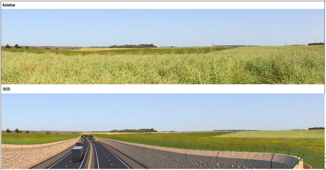
Top: Downland as existing prior to construction. Below: Visualised view from green bridge after construction of deep cutting looking east towards western tunnel portal. Images by National Highways
- Far from ‘conserving and enhancing’ the WHS, as has been regularly claimed by the scheme promoters, the infrastructure would in fact leave a far larger blot on the landscape than exists at present.
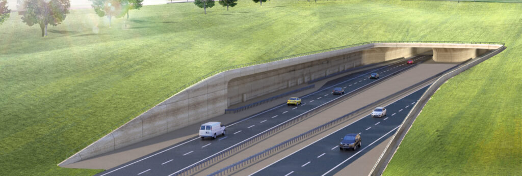
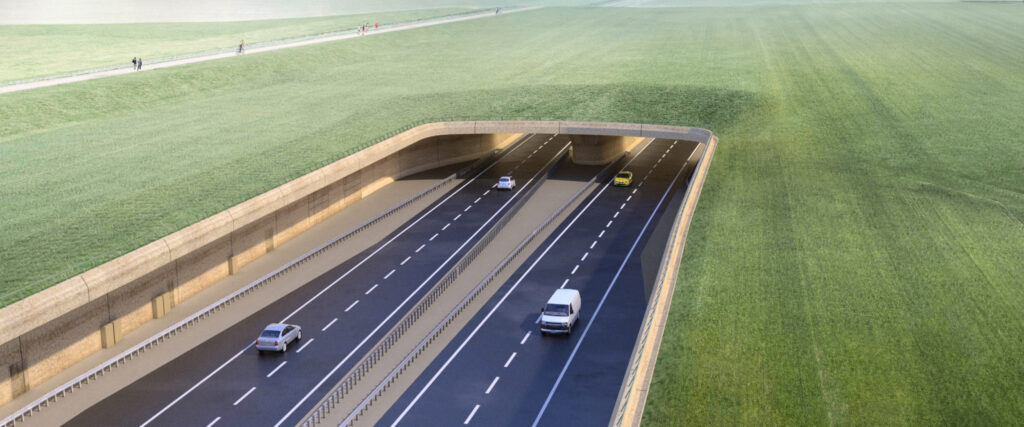
Visualisation of eastern tunnel portal through land recently purchased by National Trust. Image by National Highways
- For many people Stonehenge is a famous monument to visit on a trip to England. For others Stonehenge is a special place of spirituality, for quiet contemplation, communing with ancestors, for healing and celebration. It is also a place of archaeological and historical importance.
- The WHS designation is not only for the site’s archaeological and cultural significance, but encompasses “landscape without parallel”.
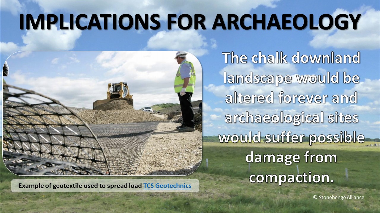
Archaeological features north of Winterbourne Stoke would be covered with tunnel chalk over geotextile. This is meant to protect the archaeology beneath but the chalk landscape would be altered forever and archaeological sites would suffer possible damage from compaction. Slide from What is planned? Part Two: The Stonehenge Tunnel.
- The A303 scheme with its tunnel over only part of the WHS would produce twin tunnel portals exiting into wide and deep cuttings through the “landscape without parallel”, leading to massive grade separated junctions at its boundaries.
- This would result in major reconfiguration of substantial parts of the WHS leaving it not only with irreparable damage to and major modification of the present archaeological landscape and its setting, but also adding another modern highway scar across the WHS.
- The road scheme would remain a dominant and incongruous feature in the archaeological record, compromising enjoyment and understanding of the WHS by future generations.
- The “mitigation” proposed by National Highways would be absolutely unable to disguise the devastating impact on the exceptional character of the WHS landscape and its setting.
The plan is to down grade the existing A303 to a fenced Restricted Byway for pedestrians, cyclists and access. The view beyond the portals would be of the deep cutting of the new dual carriageway, passers by would hear incessant traffic in the cutting. Image above: Western portal by National Highways.
Further reading
- Stonehenge Alliance: Images, maps and plans of A303 Stonehenge scheme
- Andy Norfolk, Landscape Architect, submission to Examiners on behalf of Stonehenge Alliance, 2019: Landscape and Visual Aspects of the LVIA (See summary)
- Dr David Field, Notes to the Planning Inspectorate from Issue Specific Hearing, 2019: The visible archaeological landscape effect of western portal and impact of tunnel spoil on Parsonage Down
- Dr David Field, written submission to the Examining Authority, 2019: The western end: Field systems, vistas and area beyond the Stones
- Dr David Field, Relevant Representation to the Planning Inspectorate, 2019: Area without precedent in the British Isles
- Stonehenge Alliance: Stonehenge: Much more than a monument
- Kate Fielden BA, D Phil, submission to Examiners on behalf of Stonehenge Alliance, 2019: Heritage and the Historic Environment See summary
< Briefing 1: Loss of World Heritage
Briefing 3: Archaeology at risk >
Please note: The Stonehenge Alliance has no connection with any other protest groups involved in direct action against A303 Stonehenge.
Please share