
The damage to the archaeological landscape caused by the road scheme would be permanent and irreversible.
Stonehenge is not just a landscape with a unique stone circle but a landscape packed with “… thousands, in fact millions of archaeological artefacts and other remains.” Only a limited amount would be recovered and recorded. And there is so much more to be discovered.
- What we know of the WHS today can be considered, in part, as probably a ritualistic designed landscape.
- Many of the deliberately constructed elements might have been intended to be inter-visible to emphasise, using the topography.
- Neolithic long barrows in the western part of the WHS are grouped around the head of a dry valley in which the enigmatic Wilsford Shaft appears to have been used well into the Bronze Age and later.
- Bronze Age barrows are set on ridges and slopes, respecting earlier monuments.
- The damage to the archaeological landscape caused by the road scheme would be permanent and irreversible.
- The road will cut through an unusually high density of prehistoric artefacts. Only a limited amount will be recovered and recorded.
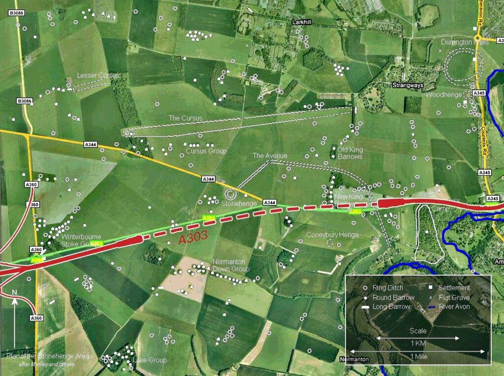
Plan of Stonehenge area overlaid a Google satellite map with designated monuments and archaeological features Source link. Proposed road has been overlaid by Stonehenge Alliance. There are many known but non designated heritage assets at the western end such as evidence of Bronze Age field systems.
- The whole of the A303 corridor is important to our understanding of the communities that built Stonehenge, especially at each end.
- The gash at the western end goes through an area of ancient field systems and linear ditches dating at least to the Middle Bronze Age. It is considered significant that areas favourable to cultivation remained uncultivated around Stonehenge itself in the Bronze Age.
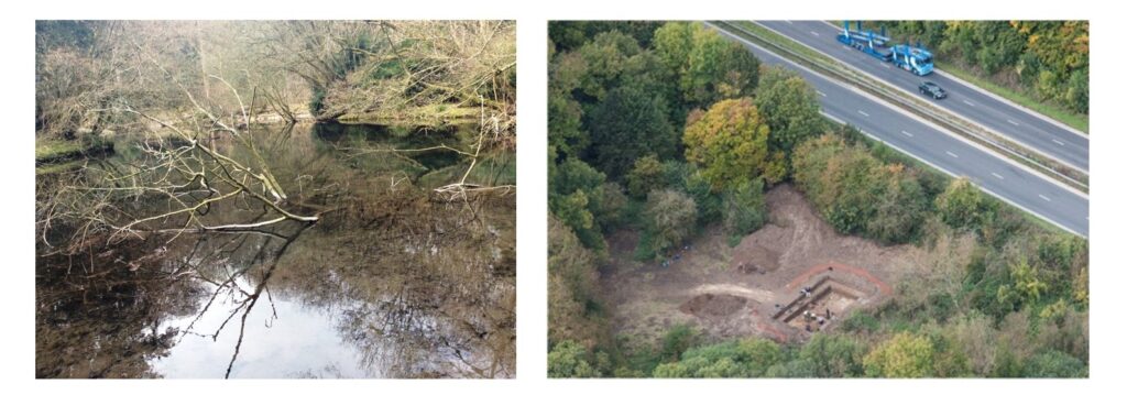
LEFT: Spring at Blick Mead RIGHT: Proximity of archaeological dig to the A303
- At the eastern end, Blick Mead, an area within chalkland spring that has been the subject of new scientific studies by the universities of Southampton, Buckingham, Tromsø, and Salzburg. The ground breaking findings suggest the potential survival of ancient DNA pollen and other ecology. Research archaeologists hope to find evidence that could recreate the landscape at the time.
- The survival of the environmental evidence has been thanks to the waterlogged conditions at Blick Mead. Archaeologists are concerned that the construction of the tunnel portal and associated flyover nearby might affect those groundwater conditions and detrimentally impact the survival of Mesolithic organic remains.
- Although Stonehenge WHS is world famous for Neolithic and Bronze Age archaeology, the latest research at Blick Mead highlights the unique importance of Mesolithic archaeology to understand life before Stonehenge.
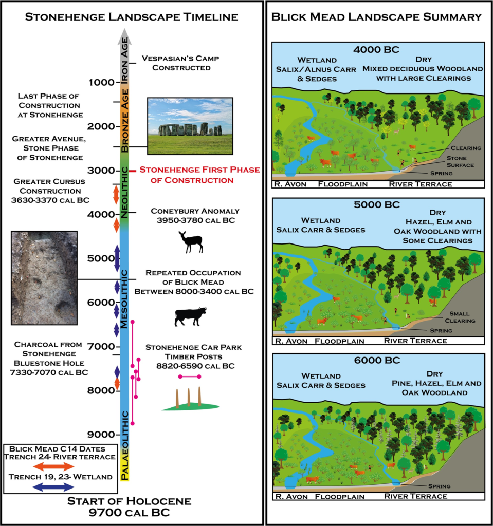
LEFT: A Timeline of the Stonehenge landscape, including radiocarbon dates from Blick Mead and other significant SWHS archaeological sites. RIGHT: A representation of the development of vegetation history at Blick Mead based on the palaeo environmental data. Source link
Further reading
- Professor Mike Parker Pearson (Talk, slides and transcript), 3 June 2021: Impact on Stonehenge archaeology Prof Parker Pearson is a distinguished expert on British Neolithic archaeology and member of the A303 Stonehenge Scientific Committee.
- See also: Evidence presented by Consortium of Stonehenge experts.
- Dr David Field, Notes to the Planning Inspectorate from Issue Specific Hearing, 2019: The visible archaeological landscape effect of western portal and impact of tunnel spoil on Parsonage Down
- Dr David Field, written submission to the Examining Authority, 2019: The western end: Field systems, vistas and area beyond the Stones
- Dr David Field, Relevant Representation to the Planning Inspectorate, 2019: Area without precedent in the British Isles
- New analysis of Blick Mead’s Mesolithic landscape | The Past
Take action!
Support the appeal against the judgment
Sign our international petition.
< Briefing 2: Landscape desecrated
Briefing 4: Strategic transport disbenefits >
Please note: The Stonehenge Alliance has no connection with any other protest groups involved in direct action against A303 Stonehenge.
Please share
